Groundwater Monitoring
"Ground Water is among the Nation's most precious resources. Measurements of water levels in wells provide the most fundamental indicator of the status of this resource and are critical to meaningful evaluations of the quantity and quality of ground water and its interaction with surface water. Water-level measurements are made by many Federal, State, and local agencies. It is the intent of this report to high-light the importance of measurements of ground-water levels and to foster a more comprehensive and systematic approach to the long-term collection of these essential data. Through such mutual efforts, the Nation will be better positioned in coming decades to make wise use of its extensive ground-water resources."
The paragraph you just read was written by Robert Hirsh as the forward to the United States Geological Survey's Circular 1217 entittled "Ground-Water-Level Monitoring and the Importance of Long-TermWater-Level Data". This page will explain the benefits of groundwater monitoring and use examples to show how this mangement tool can help you manage your groundwater resources.
Water Level Monitoring as a Management Tool
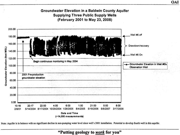
Water system managers make critical decisions every day. As you face increasing demand, you find yourself in need of a new well. Is your only option a program that involves test bores, test wells and new land purchases? Maybe not if you know the health of your source aquifer. By acting today to start a groundwater level monitoring program at your system, your option may include only aquifer testing to establish well spacing. Implementing a groundwater level monitoring program now can provide you with the information needed to further develop the aquifer you are currently using. No more test wells because you already know the water quality and the production potential of the aquifer. No more searching for an acceptable wellsite as you have one present are ready to go. How?? Consider System X. They installed Well #6 in 2001. It's now 2008 and another well is needed. Because they had an ongoing groundwater level monitoring program, they had hard data showing that the aquifer supplying Well #6 was not being over produced and could support another well, see below. The aquifer's water quality and production rate was know. All that was needed for the development of their next well was aquifer testing to determine the appropriate well spacing for the new well. The cost of the monitoring program pales in comparrison to the cost of a single dry hole, not to mention compared to the cost of a test well required to find out water quality and production potential of a new aquifer.
Call OAI to discuss setting up a groundwater monitoring for your production wells. The program will more than pay for itself.

For more on OAI's water management programs, please visit the Management link on our Home Page.
OAI MW-2 Surficial Aquifer
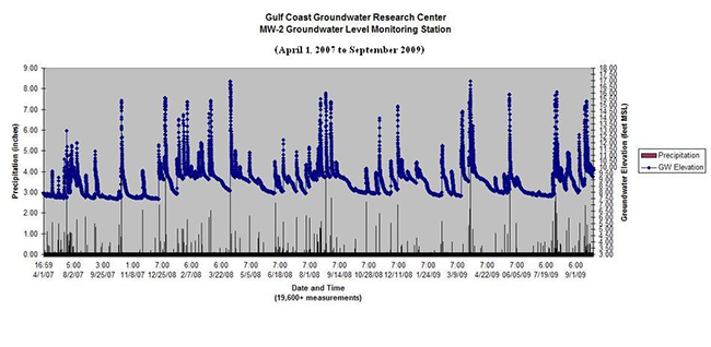
MW-2 is a 13-foot deep well located in mid-town Mobile. The water level in the aquifer responds to precipitation events of 0.75 inches or more with a rise in the aquifer's potentiometric surface. A record of the water level in MW-2 from April 1, 2007 to September 2009 shows that the base level in the aquifer tapped by MW-2 generally falls in the 7 to 9 feet above sea level range, see below.

OAI's MW-2 Gets a New Logger!
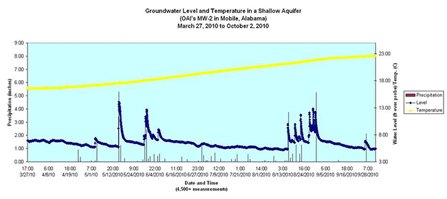
On March 27, 2010, the water level data logger in MW-2 was changed out and replaced with a data logger that records water level and water temperature. Data is recorded hourly. Since its installation, groundwater temperature has risen from 16.63 degress Celsius (C) to 22.6 degrees C. During the water year ending September 30, 2010, 93+ inches of precipitation were recorded at this location. Base water level is in the 5.18 to 5.22 foot range as seen in the relatively dry period from June 6 to August 15, 2010. During this dry period, area lawns turned brown and crunchy indicative of the dry condition. Begining August 30, 2010, abnormally dry conditions returned to the area. Area stream flow data also show the effects of the lack of precipitation and these dry times have been reported in the press.
